Thursday, April 28, 2005

Tongue and Cheek

I added a photo of myself to my Blogger profile and thought I would give some background.

Lubber's Line - SSBN 641G in the Tongue of the Ocean.

This was taken in 1982 in an area called the Tongue of the Ocean (TOTO) in the Bahamas. I'm on the USS Simon Bolivar SSBN 641 Gold at the forward end of the missile deck port side. I had just finished my watch on the Radar and ESM in time for a quick photo at the end of a very rare SSBN swim call.
Oh, and the cheek part- I'm sporting a beard. Beards were somewhat of a tradition in U.S. Submarine Service until the Navy did away with them service wide in 1985. They seemed to interfere with the EAB/OBA (face sucker) drills. Now the Canadian Navy is considering the same ban on beards (Intel Scorce: The Sub Report).

Still have the beard only a little grayer.

Volunteers keeping our shipmates informed.

The first place I go to keep up on Submarine News is:

TheSubReport.com

In the tradition of the all volunteer Submarine Service, The Sub Report has started a new program to help keep our community informed.

The Sub Report Field Reporter Program

I've signed on as well as many of my fellow bloggers and others who cover submarine related subject matter. If you work in or around the Submarine Community or have a passion for Submarine history and/or current events you may be interested in this opportunity to keep your shipmates and friends informed.

Here is the Link to The Sub Report Field Reporter Program.

U.S. Submarine Service - All volunteer for over 100 years.

Tuesday, April 26, 2005

From Chernobyl Disaster to Nuclear Submarine Disposal

Today was the 19th anniversary of the Chernobyl disaster.

Chernobyl April 26, 1986

So with that in mind, and other nuclear disasters relating specifically to Russian submarines, think about this recently floated proposal . The St. Petersburg Times reports that Alexander Rumyantsev, head of the Federal Nuclear Power Agency, or Rosatom wants to help the West dispose of its old nuclear subs.

Idle Russian Nuclear Submarines.

The Russians decommissioning and disposal of nuclear submarines has concerned the West for years. But now they think they can make money off the West (Russian Capitalists?) with lower costs and higher efficiency.

Never mind the classified technology concerns, their previous safety record makes me think "That's one Crazy Ivan!" proposal.

Monday, April 25, 2005

"It is the east, and Juliet is the sun."

This past weekend my son and I took a tour on the Russian Juliett 484 museum in Providence RI . Or as our friend Willyshake would say "It is the east, and Juliet is the sun." Romeo and Juliet [11,2]. Sorry Will couldn't resist.

It was somewhat of a traumatic experience (not the Shakespearean kind) for my 5 year old who has been to other warship museums with no issues. Maybe it was because it was a "Bad Guy Submarine" but I think it was the safety video before the tour. Part of the safety video is how to get off the boat if an alarm sounds, didn't like the alarm noise and covered his ears.

Well after couple of tries of "the alarm not going to sound" he agreed to indulge his dad and go belowdecks, but in the aft part of the forward torpedo room got scared again. That's when we meet Dave and Ric a couple of Subvets in coveralls from the Cobra Foxtrot sub that was in Seattle and is now distend for San Diego. They were on the Juliett to help in some repair and maintenance having worked on the Foxtrot and having experience with a Russian boat.

Ric and Dave were great, they saw my son's distress and immediately came to my assistance. I explained that my son was concerned that the alarms were going to go off and he didn't like the noise. Dave (the one with the hat that said Cobra COB on it) tells my son "the alarms don't work, we're here to fix them". That did the trick and he was fine after that. Now he wants to go back again to see the bad guys submarine.

Juliett 484 in Providence (Source: Juliett 484 Museum Website)

As a cold war relic this is a pretty cool thing to see. These boats were the precursor to the nuke class Echos (pun link for echo). They carried SS-N-3 cruise missiles capable of delivering a tactical nuke to a range of 400 miles. The Soviet version of the Regulus boats. NATO had some real concern about the Julietts in the 60's. These boats were some of the first to have a rubber coated hull and were very quite when running slow on aux electric motors. Early on they were tasked for a nuclear strike role but were later used to shadow NATO Naval groups and Carrier tasks forces. Key weakness was it had to surface fire the SS-N-3.

There is lots of history surrounding the one in Providence. It's owned by the group (The USS Saratoga Museum Foundation) who's trying to get the USS Saratoga set up as a museum in Rhode Island. There is some antidotal evidence that it may have shadowed the Saratoga during its career. It was also used in the film K-19 the Widowmaker.

All and all worth a look for any Submariner interested in Cold War history. As Ric one of the Subvets said on Rontini's Submarine BBS "It's an A-Gangers wet dream."

Без перевода.

Thursday, April 21, 2005

Chart 81023 and Discol Waters Rep

One more post on charts and the USS San Francisco grounding. I obtained a copy of chart 81023, the primary chart reported to have been used by the SSN711 Navigation crew, just to see what information it contained.

In my previous post “Anatahan to Guam to Discolored Waters” I had annotated chart 524 (a very large scale chart, which I had at the time) with some additional information such as Latitude and Longitude of some points of reference. On Chart 81023 I have done the same, additionally soundings are in meters so I converted some of the soundings to fathoms using 1.8 meters per fathom. For more accurate conversions between fathoms, meters and feet go here. The infamous 'Discol Waters Rep' is highlighted in the center of the chart section with Lat and Long.

Area of interest on Chart 81023 Modified (Click Image to enlarge)

In the previous post I had made an assumption on the Subs general course by saying.

From what the chart indicates in sounding data (in fathoms) the most reasonable and least obscured transit (in red) would have been west of West Fayu and Satawal islands and east of Lamotrek islands.

In the comments section of that post Bubblehead of "The Stupid Shall Be Punished" blog had pointed out that the course was probably more easterly. Now that I have looked at chart 81023 I agree. My projecting of the course west of Satawal Island was a serious error. Chart 81023 shows shoaling water of only 40 and 15 meters (21 and 8 fathoms) just southwest of Satawal. This sounding data was not on chart 524. A course east of Satawal is a clearer path (green annotation line) to take although it is closer to the discolored waters report area.

Obviously the Sub's Navigation team would not have used chart 524, which is all I had at the time of my previous post , but my error demonstrates that chart selection and the resolution of it's data points are a critical part of voyage planning for a submarine.

Chart 81023 may not have been the only chart in use at the time of the grounding, but here are some observations relating to data points and resolution that may help in understanding the situation.

1) Soundings between West Fayu and Satawal Island are 15 to 20 miles apart.
2) Distance from West Fayu to Satawal is about 48 miles with only a couple of sounding in between.
3) Distance between Lamotrek and Satawal about 40 miles with 5+ sounding in between.
4) Distance between Satawal and discolored waters report is about 25 miles with one sounding point close to Satawal.
5) The nearest sounding point to the discolored waters report is about 10 miles to the east at 1335 meters.
6) There is no sounding data for 20 miles to the west, northwest and 15 miles to the southwest of discolored waters report.

Looking back some would say more caution should have been exercised by the crew, but I'm of the opinion that bad luck and poor data played a major roll in the incident.

In saving a crippled SSN 711 the CO and crew demonstrated the courage and professionalism that exemplifies wearing US Submarine Dolphins.

The only other thing I will add is:


May god bless U.S. Navy Machinist's Mate 2nd Class(SS) Joseph Allen Ashley

Update 4/22/05 8:30 - The New London Day (registation after today) has additonal information on the Navy's investigation report including the use of chart E2203 and not 81023 as was previously reported.

Monday, April 18, 2005

"How 'bout them Boing Fish?"

Yet another sea animal post courtesy of an anonymous comment to my milamore story “How 'bout them Boing Fish?” .

It first I thought I was going to get hooked into another fish story joke or someone thought my sea story was Boring and couldn't type. I did a quick Google and found the Dwarf Minke Whale who makes the cool Star Wars sound and is sometimes called the boing fish, check out the sound it makes here or here.

Dwarf Minke Whale (Photo: Queensland AU gov website)

If your interested in some more Dwarf Minke Whale Photos go here.

The origin of this boing fish sound was a mystery for 50 years until recently. Now I have a new mystery, did the anonymous comment from Sonarmen!

Shipbuilding and Submarines at risk in New England

When it comes to the Navy, New England has had a strong bond with the Naval Service. At this country’s founding New England had at its base a maritime economy with, established shipping, fisheries and shipbuilding industries.

New England’s shipbuilding industry has designed and produced some of the world’s finest warships. From The 44 gun frigate USS Constitution to the modern Virginia Class nuclear fast attack submarines, New England shipyards have produced almost every type of warship that has served in the US Navy including submarines, frigates, destroyers, cruisers, battleships and carriers.

The Navy has also had a long established use of the natural harbors along the New England coastline including New London CT, Newport RI, Boston MA and Portsmouth NH.

But the association between the Navy and New England has been in decline since after the Vietnam War and more recently the end of the Cold War. In the current political climate the emotions of tradition and a history of efficiency and success could have little bearing. New England stands to lose more naval installations and shipyard capacity yet again.

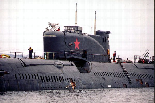
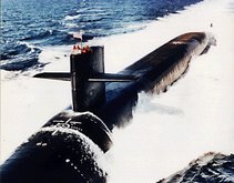
General Dynamics Electric Boat (Source: US Navy Photo)

The two things that make me think that this region is going to take a significant hit again. One is almost certain, that being the Navy’s reduction in the procurement of DDX Class Destroyers and Virginia Class Nuclear Attack Submarines. Fewer DDX Destroyers affects the Bath Iron Works and fewer Virginia Class SSNs affects the Electric Boat shipyard. With little or no commercial work both shipyards will have to reduce their workforce. This typically would impact the least skilled and least productive workers first. But there is a point where the retention of higher skilled and therefore higher paid workforce affects the cost of production and must be reduced to maintain a profit for the shipyard. At that second workforce reduction point is where capacity and shipbuilding talent is lost, possibly never to return.

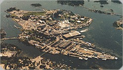
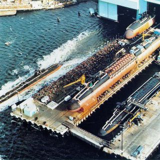
Portsmouth Naval Shipyard (Source: US Navy Photo)

The second risk is the forthcoming BRAC commission recommendations for Naval Base closure and realignment. Two facilities are up for consideration, the Portsmouth Naval Shipyard and 
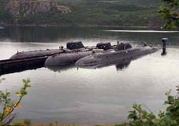
New London Submarine Base. Both installations are some of the oldest in the Navy. Portsmouth Naval Shipyard is the oldest naval shipyard operated by the Navy and New London submarine base is America’s oldest sub base.

Departing Submarine New London Sub base (Source: Navy website)

The BRAC process is to look primarily at the military value of the installations in question with secondary consideration to the economic and environmental impact to surrounding communities. So will the BRAC process be entirely non-political, not likely. The BRAC commission itself is a political animal, appointed by the president and consisting of retired flag officers and former politicians. The following is the lists of appointees:

Anthony J. Principi, former secretary of veterans affairs, from CA, chairman.
Former Rep. James H. Bilbray of NV.
Former Assistant Defense Secretary Philip Coyle of CA.
Retired Adm. Harold W. Gehman Jr. of VA.
Retired Air Force Brig. Gen. Sue Ellen Turner of TX.
Former Rep. James V. Hansen of UT.
Retired Army Gen. James T. Hill of FL.
Samuel Knox Skinner of IL, former chief of staff under President George H.W. Bush.
Retired Air Force Gen. Lloyd Warren Newton of CT.

These commission appointees bring to the table their own set of regional and service specific biases. Just as I have my bias toward for eastern Connecticut and southern Rhode Island, so too would a retired admiral from Virginia or Representative from California have his bias favoring eastern Virginia’s tidewater area or San Diego respectively. It is hard not to be influenced in some way by your previous experiences. This would be especially true when what is at stake in a base realignment will result in the loss for one community and gain for another.

The next key point in the BRAC process timeline is just one month away on May16, 05. At that time the Secretary of Defense Donald Rumsfeld will make his recommendations to the BRAC Commission and the congressional defense committees for base closures and realignment. One of Rumsfeld’s focus as Secretary of Defense has been force transformation inter-service utilization of assets, look for this to be a key aspect in his recommendations.

Other key points in the BRAC process timeline are as follows.

July 1, 05 - Comptroller General’s analysis report of Secretary of Defense Recommendations.
Sept 8, 05 – BRAC Commission’s Recommendations to the President.
Sept 23, 05 – President’s Approval or Disapproval of Commission recommendations.
If the President approves the recommendations then the Congress has 45 legislative days to act in on that approval.

Oct 20, 05 – Commissions Revised Recommendations
Nov 7, 05 – President’s Approval or Disapproval of Commission revised recommendations.
Apr 15, 06 – Commission terminates.

With a reduced fleet size and what submarine refit and repair work that exists being sent to keep the construction yards operating I see Portsmouth Naval Shipyard at greater risk than the New London Submarine Base. But, this is not the first time New London was on the hit list. In 1993 the DOD recommended the Submarine Base for realignment but the BRAC commission choose to keep the base open.

The military's presents in New England is declining and may continue to do so. This may be cost effective in the short term but in the long term I feel it will reduce America's capacity to defend itself and a key region of the country.

Update 04/18 - 2100: Bothehook makes and excellent point on how commuity support or lack there of can influence the military's decision process. Additionaly, The Sub Report links to two articles from the New England press here and here about the possible closure of the PNS.

Thursday, April 14, 2005

Animals and Submarines

This has been something of a theme for me lately animals and submarines. The dog or cat poll and the milamore fish story so I thought I'd drop a couple of photos out there and put my own captions on them.

#1 (US Navy Photo)
Trim Party on the turtle back .
All right, who blew sanitaries on me.
Duty officer, we need some Sea Lion handlers topside.


#2 (US Navy Photo)
BEAR-ing mark!
I think these submariners have a screw loose.
Just waiting for a SEAL.


#3 (Source: Unknown)
I know, we'll keep him in the Goat Locker.
Chief Billy meets the mess cooks, tonights meal?

Challenge: Add your own captions in the comments section referencing the Photo #.
Keep it clean we don't want to offend anyone.

Sunday, April 10, 2005

From Anatahan to Guam to Discolored Waters

This is an update to an earlier post I made titled "Seamounts, Escarpments, Guyots and SSN 711".

Topography
First an update on recent geological activity in the Marianas Island north of the Caroline Islands and Guam. On April 7 a major eruption occurred on Anatahan Island approximately 215 miles north of Guam at 16°35’N lat and 145°67’E long. The satellite photo below shows an plume from the Anatahan volcano as well as the volcano's relationship to Guam.

Anatahan Volcano ash plume 4/7/05 - Maranias Islands
(Photo source: NASA GSFC, MODIS Rapid Response Team)

Anatahan volcano is the most active of the 12 major volcanoes in the Marianas Islands. This is the forth eruption of Anatahan in the past 2 years and further evidence of the intense geological activity within 600 miles of the USS San Francisco's grounding and in line within 2 degrees of the Longitude for the reported "Discolored Waters" area.

Charts
In a recent article "Navy Faults navigational procedures In crash Of Sub" in The New London Day (registration required) by Robert Hamilton some of the assumptions I had made in my previous post have now been reported on. I had listed 5 charts with Notice to Mariners that were of interest. Chart 81023 is reported to be the specific chart used by SSN711's Navigation division for the transit through the area where the incident occurred. The most current chart 81023 is edition 5 with Notice to Mariners - 42/1989, 12/1990, 01, 34/1993, 41/1995, 10, 46/1996, 18/2002, 06/2005-- chart named area -Nomoi Islands. This chart covers a relatively large chuck of ocean of approximately 10 degrees of Latitude and Longitude with a listed scale of 1:1,000,000.

A second point I had made is that the first reported position of the grounding was 360 miles SE of Guam. I had calculated that the disclosed position of the "discolored Waters" 7° 45' N Lat and 147° 12' E long was actually 401 miles from Guam. The Day article reports:

The San Francisco left its homeport of Guam on Friday, Jan. 7,
headed for Brisbane, Australia. The next day, a little more than 400
miles southeast of Guam
, as sailors were sitting down to lunch, it
slammed into the sea mount in an area where official Navy charts
list 6,000 feet of water.


In order to understand the San Francisco's track and area where the grounding occurred I located an even larger chart than 81023 (Chart 524 of the western pacific) and attempted to plot the subs track. Disclaimer: Below is only a guess based on the information I've read thus far and I have no insider details. Click on chart for a larger picture.

Possible SSN 711 course (Modified section from Chart # 524)

In adding my annotations to the chart I first plotted the "discolored waters" position, represented the brown box in the center of the chart. Second I found the positions of the nearby islands for reference - Lamotrek Island, Satawal Island and West Fayu Island . From what the chart indicates in sounding data (in fathoms) the most reasonable and least obscured transit (in red) would have been west of West Fayu and Satawal islands and east of Lamotrek islands. This would have put the "discolored waters' area some distance east of the track and northeast of Satawal Island. If the sub had just gone to flank and the charted water depth was 1000 fathoms I would reason that they may have passed or been near Satawal island. this is where the charted depth (admittedly on a larger scale chart) is increasing past 6000 feet. I have highlighted in yellow the 1000+ fathom sounding just south of Satawal. Not knowing the exact position on the grounding I made a yellow box around the potential area of interest.

More on The New London Day article
On "The Stupid Shall Be Punished" Bubblehead has a post on the same New London Day article that I reference above. His take is that someone in the Navy may be spinning the San Francisco grounding story to Mr. Hamilton. Bubblehead's point seems to be that much of what was cited against the Navigation crew was not out of the norm for other operational boats such as occasional mismatched soundings at flank. Not knowing any of the details and the fact that the "discolored waters" reference was never officially part of any chart or a Notice to Mariners I tend to agree with Bubblehead on the spin point. I have yet to see any specific fact cited that would have prevented the grounding. Much of the blame seems to be attributed more on poor judgment by the crew than any solid evidence of negligence. This is probably why most of the Navigation division's NJPs were only a loss of a single level in rank and not something more severe.

If indeed someone is spinning the story at the expense of the Navigation crew, for what purpose? Here's one thing I found in Mr. Hamilton's piece that may be a reason.

The Navy has been criticized for not issuing updated charts if it
knew of a possible hazard to submarine operations in the area.
But
updates are expensive and take time. The agency that would make the
changes has been kept busy in recent years on other work, such as
terrain mapping in Afghanistan and Iraq, where accurate maps are
critical to land operations and cruise-missile strikes, the sources
said.


Is this just a statement of fact or a little CYA with the “kept busy in recent years on other work” statement?

Timing was everything
One last point I like to make. If the sub was traveling at 30 miles and hour and taking soundings every 15 minutes, they would cover 7.5 miles in that length of time. Not much time to detect the near vertical wall the sub impacted. 1000 fathoms to less than 100 all in the course of what was a few miles is a pretty quick ascent if you ask me.

Friday, April 08, 2005

Catfish or Dogfish?

Just an observation but the 3 former Submarine Officers who’s blogs I enjoy reading seem to all be cat people. Bubblehead here, Willyshake here and Chap here all have blogged about their cats.

Now I’m a dog person, and not those little rat dogs you see riding with old ladies, but real dogs the working kind. There’s a photo of my dog Barney a full blooded Chessy who loves the water.

Barney the Chesapeake Bay Retiever.

To have a little fun with the cat dog thing I thought I’d do some comparisons based on those observations. Catfish being those aforementioned former Fast Attack Submarine Officers (my assumptions) and Dogfish being this former enlisted Boomer sailor.

The clever Cats – SSN Characteristics
The hunter that prefers to stalk its prey by stealth.
A small and agile predator
Can be finicky and may choose the more tempting prey over an easy meal.
Independent minded .
Plays with its adversary and enjoys the game of cat and mouse.

The big bad Dogs – SSBN Characteristics
A lone wolf – ever patrolling its territory.
Resolute defender of his home.
Acts on his master’s commands – alert 1, alert1
May seen lethargic until provoked – beware, let sleeping dogs lay.


So I'm interested to see your preference, are you a Dog or Cat person and do you prefer SSNs over SSBNs. Click on the Take My Poll! icon below.

What is the pet and boat preferance?

Trying this poll thing again. Sorry if didn't work for you the first time. I've changed the polling service and it seems to work a lot better. I also turned IP checking off to allow multipule votes from one IP address, just in case your a Florida moveon.org type voter. You can also add comments to your vote as well.

Thursday, April 07, 2005

Biologics and the Milamore Fish

When I made boomer patrols one of the places I would hang out for some rare down time was in control. I wasn’t into playing cards or watching the Blues Brothers movie on the mess decks for 15th time. It was natural for a NavET to be in control and the navigation center working watchstation quals while off watch. Occasionally while off watch I could even catch a rare periscope liberty when we came to PD just to ventilate and not as part of a drill.

During one quite mid-watch I struck up a conversation with a junior officer JO who was standing the Officer of the Deck OOD. I noticed that when the watch was routine (no drills scheduled) he liked to turn up the passive sonar speaker on the conn and listen to the local biologics. In my conversation with the JO I found out that he had a master’s degree in Oceanography and marine biology. One of the things he liked to do was listen to the biologics and try to identify what was making a specific sound. Being curious I asked if he could teach me to ID a few of the sounds.

After listing to a few clicks, moans and whistles he would identify the species of marine life producing the sound. It was all pretty interesting to me having been an avid salt water fisherman. All of a sudden I hear a series of load *POPS* and immediately asked what made those sounds. The OOD says as a matter of fact “Oh, that was a Milamore fish”. I had never heard of a milamore so I had to ask him to explain what a milamore was. Here’s what I got for my trouble.

“The milamore fish is a long slender fish much like a mackerel and travels in large schools. Occasionally when spooked the lead fish in the school would stop abruptly causing the fish that were following to rear end each other and thereby put their head up the butt of the fish in front of them. When they were able to extricate each other you could here the POP sound for A MILE OR MORE.”

Very funny, he hooked me on that one. Before leaving control, a little less gullible, I promised the OOD the next time he had me as the ESM operator at PD I’d make sure to report all the hammer4 and henweighs I could. What’s a hammer4, to strike nails. What’s a henweigh, about 4 pounds. NATO classifications and naming of Soviet equipment sometimes made about as much sense as henweighs and hammer4s but a fish a named a milamore? I should have heard that one coming, well ah, maybe by a mile or more.

Tuesday, April 05, 2005

Sleeping next to a dud?

The Sub Report has a link to the news.Telegraph piece in the UK that states that some former nuclear weapons scientists are saying the W-76 warhead is flawed and my not work as intended. The W-76 is the primary warhead used in the Trident C4 missiles. The D5 missiles also can be loaded with the 100kt W-76 as well as the larger yield W-88 warhead. But the NYT "A fierce Debate on Atomic Bombs from Cold War" (subscription required) frames it as more of a debate on whether to upgrade the existing stockpile of W-76s or to extend their life.

Trident Fleet Ballistic Missle (US Navy Photo)

The debate on the W-76 flaw is not new, in fact the Albuquerque Journal had an article on this back in Oct 04 and the Free NewMexican in July of 04.

So did I make patrols with a bunch of duds? Not likely. The problem appears to be with the secondary detonation which makes things boom even louder. Not much comfort if you were on the receiving end of a still multi kiloton nuclear detonation.

Sunday, April 03, 2005

Seamounts, Escarpments, Guyots and SSN 711

The USS San Francisco recent grounding and subsequent NJPs of the Navigation division personnel got me to thinking. If one of the contributing factors for the grounding was poor chart maintenance what hydrographic and chart information could I find with my limited resources?

The exact position of SSN711’s grounding is classified but it is has been reported that the incident occurred approximately 360 to 400 miles southeast of Guam. Additionally the National Geospatial-Intelligence Agency has reported that a “discolored waters area” that appears on a 1999 Landsat satellite image could be a previously uncharted seamount. The position of the “discolored waters” area in question is reported as 7° 45.1’ N Latitude and 147° 12.6’ E Longitude. Guam, where the USS San Francisco started its voyage, position is 13° 27’ N Lat and 144° 13’ E Long.

Micronesia (Source: CIA - World Factbook)

Each degree of Latitude is 60 nautical miles and at 10 degrees Lat each degree of Longitude is still 59 nautical miles (Cos Longitude x 60). Using pythrethrum theorem A2 + B2 = C2 we can verify the distance between Guam and the Seamount. Where A is the difference in Lat miles (13 – 7) x 60 = 360 miles and B being the different in Long mile (147 – 144) x 59 = 177 miles we can calculate the diagonal distance. I came up 401 nautical miles between Guam and the reported Seamount position. I hope I did the math right on this, but it matches the upper end of the reported distance from Guam where the sub grounded. This is essentially the area between Guam in the Marianas Islands and Caroline Island ridge of Micronesia.

The area transited by SSN711 has some of the most extreme changes in bathymetric topography in the world. In fact Marianas Trench just southeast of Guam has the deepest point in the worlds oceans at 38,518 feet deep. To put that in perspective the elevation of Mt. Everest is only 29,035 feet above sea level. As an illustration I included the below hydrographic image of the western pacific that include the sub's transit route.

Pacific Bathymetry relief (Source: National Geophysical Data Center)

In the below image I took a section of the above NOAA relief and given reference location of Guam and the Latitude of 0° for the bottom of the image I was able to create a very rough illustration (yellow box in next image) of where the sub could have struck the seamount. Click on any image for a larger view.

Hydrographic with SSN711 estimated track (Modified subsection of previous relief)

I took three reported facts into account in adding my notations above. First the general direction of the ship’s transit was on a southeast heading. Second the distance of 360 to 400 nautical miles from Guam and last the accident occurred before reaching the Caroline Island Ridge. Now none to this is exacting only my best guess. The actual position could be a little further south than I indicted.

Seamounts and Guyots are volcanic in origin and the Marianas chain is volcanically active. A large number of the Caroline Islands are also volcanic in origin but do not have any active volcanoes. The Caroline Islands did have a 5.8 earthquake in 1998.

South Pacific Volcano breaking ocean surface. (Source: Volcano World website)
This photograph was taken by CSIRO - Australia.

The above photo although not from the area of the grounding does show how an active underwater volcano can abruptly appear. The underwater topography of the western pacific is a dynamic and changing environment.

The damage to the sub from the grounding was significant and appears to come from what could have been a near vertical face of the seamount.

USS San Francisco damaged bow section. (Source: US Navy Photo)

So what do the charts say about the area in question? I was unable to find any Navgation charts of the western pacific at my local boatyard ship's store and had to order a chart on-line . I haven't recieved that chart as of this writing. I did look into what commercial charts cover the USS San Francisco's transit route. The following are the NIMA chart numbers and Notice to Mariners of possible interest:

Chart# Ed# Notice to Mariners
81002 6 30/1990, 43/1995, 24, 42/1996, 18/2002 --- Caroline Islands Western part
81004 4 06/2005 --- Marianas Islands
81023 5 42/1989, 12/1990, 01, 34/1993, 41/1995, 10, 46/1996, 18/2002, 06/2005--Nomoi Islands
81025 3 N38/2004 --- Military use only
81133 4 47/1985, 27/1986, 15/1988, 30/1989, 15/1991, 06, 14, 34/1993 --- Caroline Islands

It will be interesting to see what information is contained in the listed charts and Notice to Mariners. It should be noted though, that reports of the Navigation crew's NJPs cited negligence in chart maintenance, but never indicated that a specific piece of missed information would have prevented the grounding.