Topography
First an update on recent geological activity in the Marianas Island north of the Caroline Islands and Guam. On April 7 a major eruption occurred on Anatahan Island approximately 215 miles north of Guam at 16°35’N lat and 145°67’E long. The satellite photo below shows an plume from the Anatahan volcano as well as the volcano's relationship to Guam.
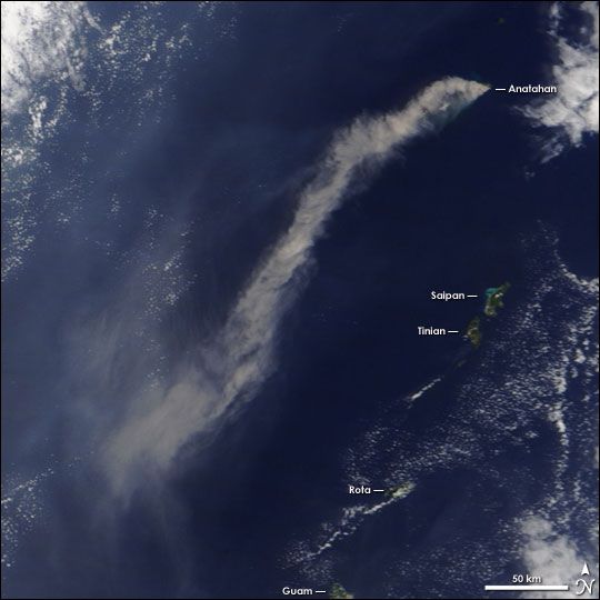
Anatahan Volcano ash plume 4/7/05 - Maranias Islands
(Photo source: NASA GSFC, MODIS Rapid Response Team)
Anatahan volcano is the most active of the 12 major volcanoes in the Marianas Islands. This is the forth eruption of Anatahan in the past 2 years and further evidence of the intense geological activity within 600 miles of the USS San Francisco's grounding and in line within 2 degrees of the Longitude for the reported "Discolored Waters" area.
Charts
In a recent article "Navy Faults navigational procedures In crash Of Sub" in The New London Day (registration required) by Robert Hamilton some of the assumptions I had made in my previous post have now been reported on. I had listed 5 charts with Notice to Mariners that were of interest. Chart 81023 is reported to be the specific chart used by SSN711's Navigation division for the transit through the area where the incident occurred. The most current chart 81023 is edition 5 with Notice to Mariners - 42/1989, 12/1990, 01, 34/1993, 41/1995, 10, 46/1996, 18/2002, 06/2005-- chart named area -Nomoi Islands. This chart covers a relatively large chuck of ocean of approximately 10 degrees of Latitude and Longitude with a listed scale of 1:1,000,000.
A second point I had made is that the first reported position of the grounding was 360 miles SE of Guam. I had calculated that the disclosed position of the "discolored Waters" 7° 45' N Lat and 147° 12' E long was actually 401 miles from Guam. The Day article reports:
The San Francisco left its homeport of Guam on Friday, Jan. 7,
headed for Brisbane, Australia. The next day, a little more than 400
miles southeast of Guam, as sailors were sitting down to lunch, it
slammed into the sea mount in an area where official Navy charts
list 6,000 feet of water.
In order to understand the San Francisco's track and area where the grounding occurred I located an even larger chart than 81023 (Chart 524 of the western pacific) and attempted to plot the subs track. Disclaimer: Below is only a guess based on the information I've read thus far and I have no insider details. Click on chart for a larger picture.

Possible SSN 711 course (Modified section from Chart # 524)
In adding my annotations to the chart I first plotted the "discolored waters" position, represented the brown box in the center of the chart. Second I found the positions of the nearby islands for reference - Lamotrek Island, Satawal Island and West Fayu Island . From what the chart indicates in sounding data (in fathoms) the most reasonable and least obscured transit (in red) would have been west of West Fayu and Satawal islands and east of Lamotrek islands. This would have put the "discolored waters' area some distance east of the track and northeast of Satawal Island. If the sub had just gone to flank and the charted water depth was 1000 fathoms I would reason that they may have passed or been near Satawal island. this is where the charted depth (admittedly on a larger scale chart) is increasing past 6000 feet. I have highlighted in yellow the 1000+ fathom sounding just south of Satawal. Not knowing the exact position on the grounding I made a yellow box around the potential area of interest.
More on The New London Day article
On "The Stupid Shall Be Punished" Bubblehead has a post on the same New London Day article that I reference above. His take is that someone in the Navy may be spinning the San Francisco grounding story to Mr. Hamilton. Bubblehead's point seems to be that much of what was cited against the Navigation crew was not out of the norm for other operational boats such as occasional mismatched soundings at flank. Not knowing any of the details and the fact that the "discolored waters" reference was never officially part of any chart or a Notice to Mariners I tend to agree with Bubblehead on the spin point. I have yet to see any specific fact cited that would have prevented the grounding. Much of the blame seems to be attributed more on poor judgment by the crew than any solid evidence of negligence. This is probably why most of the Navigation division's NJPs were only a loss of a single level in rank and not something more severe.
If indeed someone is spinning the story at the expense of the Navigation crew, for what purpose? Here's one thing I found in Mr. Hamilton's piece that may be a reason.
The Navy has been criticized for not issuing updated charts if it
knew of a possible hazard to submarine operations in the area. But
updates are expensive and take time. The agency that would make the
changes has been kept busy in recent years on other work, such as
terrain mapping in Afghanistan and Iraq, where accurate maps are
critical to land operations and cruise-missile strikes, the sources
said.
Is this just a statement of fact or a little CYA with the “kept busy in recent years on other work” statement?
Timing was everything
One last point I like to make. If the sub was traveling at 30 miles and hour and taking soundings every 15 minutes, they would cover 7.5 miles in that length of time. Not much time to detect the near vertical wall the sub impacted. 1000 fathoms to less than 100 all in the course of what was a few miles is a pretty quick ascent if you ask me.


2 comments:
Excellent post! From what I've read, though, I think they were on more of an easterly course...
Thanks for the feedback Joel. I haven't been following grounding as closely as you have on your Blog. Most of the info I've have is public NYT, The New London Day and various press releases. There is probably more in the message boards like Rontini's Submarine BBS but I haven't been reading them. If the sub's course was more easterly then indeed the discolored waters area was a factor, althought the crew had no way of knowing that with the information they had.
Post a Comment