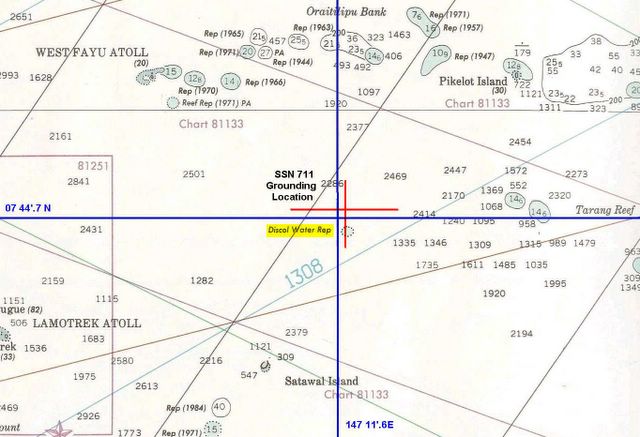
Chart 81023 plot of SSN 711 grounding
(Click on Image to enlarge)
There are two positions in the report, the ship's deck log position and the RLGN data position. Plotted in Blue for deck log and Red for RLGN recorded positions. Here are the report entries:
290. (U) The QMOW on watch at the time of the grounding, ET2(SS) ****, said he was knocked unconscious for a short time when the ship grounded. According to the ship's Deck Log, the Grounding occurred at 07 44.7' N, 147 11.6' E. A relieving QMOW, ET2(SS) **** , stated that this Deck Log position was taken from the RLGN remote touch screen display that was paused some time after the grounding.
291. (U) Based on a second-by-second analysis of the ship's deceleration recorded in RLGN channel 1 data, the ship grounded at 1142K (and 20 seconds) at 07 45.5' N, 147 12.3' E.
The Chart I used above is 81023 which is a general navigation chart and the one the Navy cites as containing the "discol waters rep". The Discolored Waters Report is 3 nautical miles south of the actual grounding and is from a 1966 Japanese Notice to Mariners that was originally reported in 1963. This data point was not on the E2202 chart used by the Navigation crew and was not noted in the SUBNOTE provided for their transit. Chart E2202 is a bottom contour chart and was considered to have been more accurate due to the greater density of sounding data. I noted chart 81023's poor sounding data in a previous post on this blog. Chart E2202 was up to date and the Navigation crew had all applicable NTM entered.
Although not transferring the "discol waters rep" from Chart 81023 to E2202 was cited as one of the contributing factors to the grounding, it is not a responsibility the Navigation crew shares alone. I'm of the opinion that the originator of the SUBNOTE and the Defense Mapping Agency share equal responsibility for not including on chart E2202 a navigation hazard identified back in 1963.


1 comment:
My God the soundings are all over the place. How do you even set Red and Yellow? Note how rapidly the soundings change in a lot of places.
This is an area that has two kinds of islands - ones that stick up above the surface, and ones that don't. All so easy to see with hindsight. What a tragedy.
Post a Comment